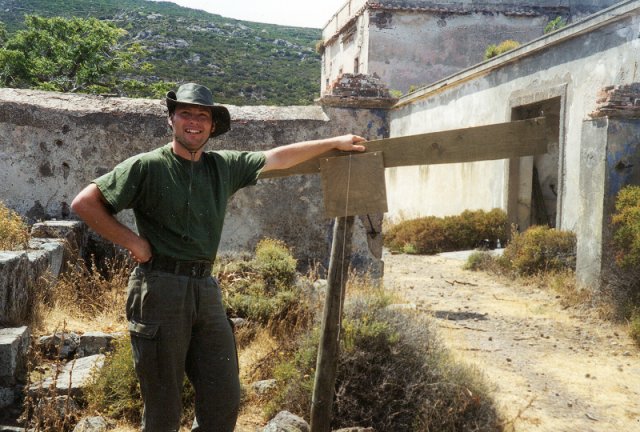
Mike Leahy with Quadrant outside the prison filming site
If the observer was on the North Pole the Pole star would be directly above him. Viewing over several hours he or she would see all the stars apparently rotating about the pole star. An observer situated on the equator (ie. on the 'band' around the Earth widway between the two poles) would just about see the pole star on the distant Northern Horizon and all the stars apparently moving about this point. For latitudes between the Norhern Pole and the equator the pole star has a different corresponding angle with respect to the northern horizon. This angle being equil to the latitude of the observer.
By the way the Pole Star is not visible to observers below the equator and so another method has to be used to estimate the latitude in this case.
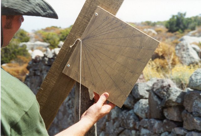
Close up of Quadrant
Mike Leahey built a simple quandrant, a device to measure the angle of the pole star. The quandrant he made actually measured the angle between a weight on a string (which always hangs vertically) and the pole star. This gives an angle which is the complement of the latitude ie. latitude = 90 - measured quadrant angle.
On one evening in Capraia, through the twilight with the brighter stars just about visible Mike and I measured the pole star angle and were thus able to estimate the Islands Latitude:
Latitude - Capraia 43 degees North of the equator.
T = 2 x PI x (s.r. (L/G))
where PI = 3.14
s.r. means the square root
L = length of the pendulum
and G is a constant of gravity = 9.81
which for a 4m pendulum gives T = 2 x 3.14 x s.r.(4/9.81) = 6.28 x 0.639 = 4 seconds
So a rather easy to remember rule is that a 4 m pendulum takes about 4 seconds to swing back and forth.
The Rotation of the Earth
The Earth turns once (360 degrees) in 24 hours. So in one hour the earth rotates by 360/24 = 15 degrees, which is also equil to 1 degree of rotation in 4 mins.
Longitude on Capraia
On Capraia the ideal situation would have been to wait till noon start the pendulum swinging and keep swinging until the radio picked up the 12:00 time signal from Greenwich. The total time the pendulum 'swung' for would have been equivelent to the longitude (4 mins = 1 degree).
However we found that the strongest signal was obtained from an Italian radio station and unfortunatly it did not always give the time on the hour. Therefore we took the first reliable time signal we got, set the pendulum swinging and then counted (timed) till noon on the island. The calculation goes something like this:
Time picked up on radio: 12:24 Europian time which is equal to 10:24 GMT
Pendulum swings to noon on island = 841 swings = 56 min
so time for Capraia noon =
radio time + extra time measured by pendulum = 10:24 + 0:56 = 11:20 GMT
Time difference between GMT noon (12:00) and Capraia noon (11:20) = 40 min
4 mins = 1 degree of longitude and so therefore Capraia is at 40/4 = 10 degrees longitude.
because noon on Capraia (11:20) is before noon in Greenwich (12:00) we know that Capraia is East of Greenwich.
Putting this all together we get that Capraia's position on the Earth :
Latitude: 43 degress North, 10 degrees East
How accurate is this ?
In early times it was thought the world went round the Sun in a perfect circle. Kepler, the famous astronomer/mathamatican discovered, after years and years of calculations, (see Arthur Koestlers wonderful book - the Sleepwalkers for the story) that the Earth actually goes round the Sun in an elipse (almost circular, but not quite). The consiquence of this is that the earth speeds up and slows down on its journey around the Sun. This means that if you use the Sun as a clock (i.e. a sundial) it actually gains and loses time from one day to the next. Only exactly a year later will the day be the same length (ignoring the odd coincidence elsewhere in the year). So although a sundial can be made to be very accurate it is only so if you know on what part of the earths orbit we are on!
A changing solar time isnt much use for our busy and quick lives, and so clocks have been devised which actually give an 'average' solar time. If you like, our clocks give an average time based on all the days of the year (in fact the real situation is more complex still, due to the earths rotation changing slowly leading to 'leap seconds' being introduced every few years but we will pass this by for now).
Because of the changing length of the solar day (time read by a sundial) the longitude measurement made using local noon always has an error associated with it. The difference between sundial time and the average clock time is called the 'Equation of time'. There are a few days in the year when sundial time is the same as the clock time e.g. in mid April, mid June, early Sept. and late Dec. For all other dates there is a slight error. The maximum error is about 16 minutes in early Nov. and mid Feb. A nice book about all this is 'Sundials' by Albert Waugh (ISBN 0-486 22947 5).
Mike and I made a couple of attempts at measuring the longitude just for fun. In July the 'Solar' error described above is about 6 mins (about 1.5 degrees worth of longitude) but our best measurement was made later on in the year in Sept where the error is very small. So as far as this is concerned the error was never very much, and so by 'hook or by crook', or just plan 'jamyness' our longitude measurement came out about right !
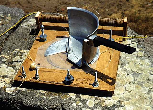
The short wave crystal set radio used to pick up time signals for the longitude estimate
What really happened on the island!
The Rough Science radio was designed to pick up short-wave signals so that we could attempt to pick-up the time from the BBC World Service. After hours and hours of experimenting we managed to reliably pick up a few short-wave signals. None of these, as it turned out, were the BBC but we did pick up an English programme from Swiss Radio International as well as German, French and Arabic speaking stations. For the TV programme we needed to be able to record the sound from the radio. The problem was that every time we plugged the TV gear into the radio it de-tuned the crystal set and no strong stations could be heard! Eventually we had to modify the coil and capacitor so that the radio picked up the strongest signal around. Luckily this was an Italian medium wave station that we managed to record and this gave us the time. So the real magic of our short wave radio couldn't actually be filmed. As someone once wrote, 'magic things are fond of deceptions'!
For more details about the Radio see the Rough Science booklet or the 'make your own radio' on the OU web site for details. I have since made a copy of the Capraia radio at home. I never managed to test out the radio at night on our island location and it was fun to see that not only did the radio work (based on the web site instructions) but it worked really well early evening/night. Also I was only using about 10 m of wire for the antenna and no good earth. It would be fun to see what 'record' could be made of the best stations (i.e. furthest away or most unusual) picked up by people using this simple radio.
(All photos: Jonathan Hare)
* click below to go to
Making your own radio
* click below to go back to
Rough Science page
THE CREATIVE SCIENCE CENTRE
home | diary | whats on | CSC summary | latest news